The Jagged Peaks of Pinnacles | Coromandel
The Kauaeranga Kauri Trail, aka the Pinnacles Walk, is a beautiful track situated in the lower half of the Coromandel Forest Park.
The Peninsula is a perfect place to wind down from city life. It is about two hours away from Auckland, with activities to cater for all – from beaches to forests and waterfalls.
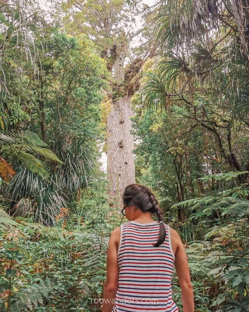
The area also contains Kauri trees. Kauri is considered one of the mightiest trees in the world. The largest and oldest tree lives in the Northland of New Zealand. Tane Mahuta is estimated to be over a thousand years old.
Back to the trail: remnants of giant Kauri stumps and abandoned felled logs tell the story of the olden days when loggers lived and worked in the hills to log Kauri trees as their livelihood.
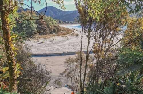
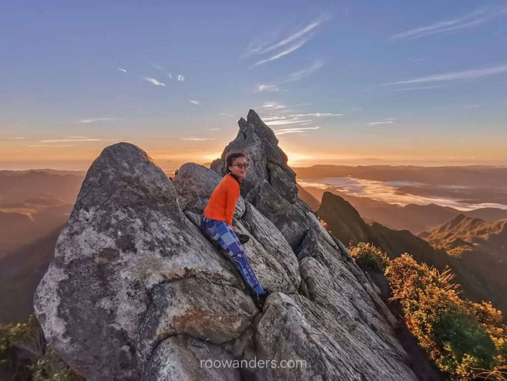
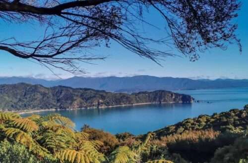
The best part of the track, however, is the jagged summit of pinnacles, where panoramic views extend beyond the bushes to the coast.
I’ve also climbed another set of pinnacles elsewhere. The trek to Mulu Pinnacles in Sarawak, Malaysia, is way more difficult than this pinnacles in New Zealand!

The Track
The tramp is doable as a day-long return tramp or broken into an overnight stay in the Pinnacles Hut. Most trampers choose to do an overnight tramp for the sunrise.
It takes about three hours to reach the summit, about 6 km from the remote carpark.
The best way to reach the carpark is by car, about two hours from Auckland or Tauranga via major highway 1 or 2, followed by Highway 25, and ending in Kauraeranga Road.
Our Plan
The initial itinerary was to drive to Coromandel and start the track after our 5-day campervan adventure in the Northland.
But a heavy downpour and sudden lockdown in Auckland changed that. We continued our journey along Highway 2 to Tauranga and stayed in the city for two nights before returning to Coromandel.
The last 10 km towards the carpark was unsealed with limited mobile connectivity.
We left our camper car sans valuables and began the walk in the late afternoon. Remember to remove any valuables or visible objects and block up your windows if it is your abode.
Clean Shoes Protect Trees
We scrubbed and sprayed the soles of our shoes with some disinfectant before entering the reserve.
Posters plastered around certain reserves educate on the spread of fungal plant disease – Kauri dieback – that can kill native kauri trees of all ages.
According to DOC, Kauri is one of the world’s mightiest trees. New Zealand’s largest and oldest tree – Tane Mahuta – located in the Northland is a Kauri. It is estimated to be over a thousand years old. Those cleaning booths outside certain parks on the north island are meant to staunch the spread of the fungal disease.


Swing Bridges, Steps, and the Hut
We crossed a big swing bridge and continued along Webb Creek.
In between the bridges and hut were plenty of steps, both manicured and rugged in the form of clustered tree roots.
In all, the track was short and easy for those with a reasonable amount of fitness. It could be challenging for those with weak knees.
We were walking among the trees and were protected from the elements.
The track would be very muddy after a downpour, so watch your steps!
The Hut
The Pinnacles Hut is an 80-bunk serviced hut. Bookings are made online before the track. As it makes for a perfect short getaway, weekends tend to be fully booked relatively early during peak tramping season. Book early to avoid disappointment.
The hut warden on duty that evening showed us photos from his collection of the views from the summit taken under different hues – orange-yellow sunrise, bright white daytime, and pinkish-purple sunset. Clouds fogged the sky that evening, but he told us they’d disperse by morning.


The hut is so big that it reminded me of Luxmore Hut in the Kepler Track (sleeps 54) and the Routeburn Falls Hut (sleeps 48).
The cooking space is generous and separated away from the bunk rooms, which are located on the next level. Tables and benches are lined up in the kitchen and on the patio. Cooking gas is provided.
The Summit
We began the trek to the summit about an hour before the forecasted sunrise. The distance between the hut and the summit is a short detour from yesterday’s route, followed by a steady steep climb with climbing ladders in the final stage of the ascent, the total distance: 1 km.


It was a mix of fun and fear manoeuvring between the boulders with the sole light source in my headlamp.
Fences around the summit platform prevent falls, but several trampers tend to veer off and go over the boulder for better views of the bush, mountains and coastline of Coromandel.

Return
We traced the same route we took the day before. If time is not your concern, consider doing the alternative way to complete a loop. Billygoat Track takes an hour more, but it leads back to the same carpark.
Pointers
- DOC campsites along Kauraeranga Road for a night. Great plan for those looking for cheap campsites. Booking is to be made online.
- Check the weather. Bad weather = danger/ no views. A dilemma between booking early and checking the weather.
- Jandals. You could walk in jandals as my partner did. But your toes may bleed.
- Wear layers. It was warm during the day but chilly as we wait for the sun to rise at the summit.
- Camera stand. Capture the time-lapse of the beautiful sunrise or milky way.
Video


You May Also Like
Great Walk Series: Abel Tasman Coast Track

New Zealand Holiday Job #8: Flower Packing