
My Kerinci Experience: Tallest Volcano of Indonesia
Kerinci, the tallest volcano in Indonesia at 3,805 m, has been on my list since 2019.
Ever since I climbed my first major volcano in Indonesia, Rinjani at 3,726 m in Aug 2017, and Semeru at 3,676 m in Aug 2018, I thought I’d climb Kerinci in Aug 2019.
But joining a group of like-minded friends, or finding one to make a group, was especially difficult for Kerinci.
Unlike Semeru and Rinjani, Kerinci isn’t popular.
Situated in Sumatra, getting to Kerinci is a logistical challenge, as opposed to travelling to Rinjani in Lombok, and Semeru in Java.
This post will not show you how to DIY your journey up the summit from the airport. The steps are beyond me, and, honestly, getting a guide is highly recommended for the mountains where the weather is erratic, and where the people speak a different tongue.
Instead, this post will be about my journey with a group towards Kerinci, and inform you of the terrain and expectations of the hike, compared to #3 Semeru and #2 Rinjani.
TDLR: Is climbing Kerinci tough? No, when compared to Rinjani.

I was at Kerinci in May 2024. This post contains affiliate links that cost nothing to you but support my blog! It may also be updated periodically. Cheers!
Rambles You Can Skip: My Relationship with The Three Volcanoes
This section is as it is – a place for me to throw in my thoughts for the future me to read about and reflect on.
Rinjani happened in 2017 as I was on the roll on hiking expeditions.
I had recently completed Bromo and Ijen – two smaller but equally stunning volcanoes of Java – in April 2017, and wanted to hike more volcanoes and catch the sunrise above the clouds.
I’m sure there might have been a bit of ego here to show that I’ve hiked a volcano above 3000 m.
As with Kota Kinabalu of Malaysia, outdoor enthusiasts in Singapore who were recently bitten by the hiking bug will naturally want to put Rinjani in Indonesia in their collection of tough hikes.
Curiosity was definitely there to push me to see what’s at the top of Rinjani and test my endurance.

Digression: I have not climbed KK, since the cost doesn’t quite justify it, and the views do not look inviting. Maybe in the future, when I’ve exhausted my list of activities to do and have excess cash and annual leaves/ time to spare…
With the second-tallest volcano completed in 2017, I thought of climbing Semeru.
My first trip to Indonesia in April 2017 to Bromo led me to face Semeru from the bottom since Bromo and Semeru were born from the same ancient volcanic system.
Again, I was curious. What would Bromo look like from the top of Semeru, and what’s the difference between Rinjani and Semeru?
Fortunately, I found a group of 7 to join me and hike Semeru.
Humans can never be so easily satisfied.
With Semeru and Rinjani, the third and second tallest volcanoes of Indonesia completed, I was curious again about the tallest volcano – Kerinci. What’s climbing Kerinci like?
But not many people want to climb Kerinci! It’s not as popular as Rinjani or Semeru, and getting there is a chore, as we’ll explore later.
So the idea to do it in 2019 was postponed. I went to Georgia to hike and visit Azerbaijan and its exclave Nakhchivan, instead.
Then COVID-19 happened, and my stay in New Zealand on a Working Holiday visa was lengthened to two years.
When I finally returned to Singapore, I began to search for friends and old hiking connections for trips to Kerinci.
And that’s when I found a friend – the crux and master of bringing a network of hikers to his trip – organising a tour to Kerinci in May 2024. That’s my chance!
Day 1: An arduous 10-hour long bus ride
Flight from Singapore to Padang
We flew from Singapore, transiting at Kuala Lumpur International Airport, to Minangkabau International Airport of Padang, in Sumatra.
Unlike Semeru and Rinjani, there are no direct flights from Singapore to the nearest international airport to Kerinci. I took SIA – it was on offer, and there are many budget carriers – to Juanda International Airport for Semeru, and Scoot to Lombok International Airport for Rinjani.
I like to use skyscanner to find the cheapest flights available.
Bus Ride
About twenty of us boarded a chartered bus to Kersik Tuo – a village that primarily receives travellers who are there for Kerinci or to enjoy the cool mountainous climate and tea.
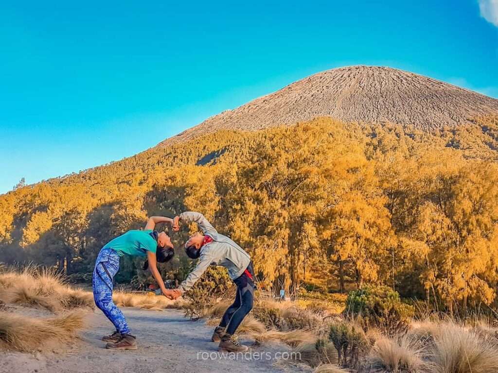
Tea plantations and farms – I saw chilli, cabbage and potatoes – surround the forest leading to Kerinci, a free-standing mountain similar to Kilimanjaro, Mt Fuji, and Taranaki of New Zealand.
We had several toilet stops over the 10-hour ride (noon to 10 PM) on narrow, curvy, dancing roads. Most of these stops were at the petrol stations with shops selling snacks and drinks.
Dinner was at a rest stop/ eatery. I had rice with soup for IDR 25k and bought two 1.5L water for IDR 14k. Note: Buy your water along the way at the stops and not at the airport! Prices easily double!


Google Maps revealed a 6-hour journey, but our bus took 10. Going via vans might be faster, but I believe it’ll never be within 6 hours – 8 might be likely for smaller vehicles.
We break off for the night at one of the homestays in Kersik Tuo.

Day 2: Hiking to Camp 3
Truck ride & short walk to the Guardhouse
After a sumptuous breakfast of nasi goreng, soup, potato cubes and fried vegetables – all spicy! – we boarded the trucks towards Kerinci.
It was a 10-minute ride from Kersik Tuo village to somewhere near the guardhouse. We travelled from proper smooth-coated tarmac roads to rocky farm roads. A towering Kerinci beckoned from afar, while tea plantations, and later vegetable farms, flanked both sides of the pebbly road.
The trucks dropped us somewhere where the roads became too narrow to venture further. We finished the last stretch – about 10 mins – on foot. Not the nicest walk over protruding pebbles!


To Pintu Rimba (1,810 m)
A giant gate indicated we’ve reached!
We snapped a few photos with the gate, and a pointy green wall with the words Kerinci Seblat National Park etched over it. Then a briefing with the lead guide over a map within the vicinity, and we were off into the expectedly muddy forested terrain of the mountain (8.30 AM).


To Pondok Bangku Panjang (1,889 m) – 0.5 hour
This section was straightforward and took under 30 minutes from the gates (9 AM). Pretty much like walking in MacRitchie.


To Batu Lumut (2,020 m) – 0.5 hour
Another 30 minutes for me from the previous checkpoint to Batu Lumut, which had an old faded map (9.30 AM).


To Pondok Panorama (2,225 m) – 0.5 hour
Nothing too taxing either from Batu Lumut to Pondok Panorama, but steps were increasingly higher. Another 30 minutes for me (10 AM).


To Shelter 1 (2,505 m) – 1.5 hour
Once we left Pondok Panorama towards the Shelter/ Campsites, the time to reach the subsequent checkpoints became increasingly longer, and the route much tougher.
Here it took me 1 – 1.5 hours to hike from Pondok Panorama to Shelter 1 (11.20 AM). We squeezed through our first set of muddy gullies, where hands rather than hiking sticks are much more apt.


Shelter 1 is a relatively flat land, excellent as a campsite, but too far away from the summit.
We had our packed bento lunch, and recharged for about an hour, enjoying the breeze and the passing mist. Inert bodies soon grew cold from the cold winds, and colourful jackets and outer shells started popping out.


To Shelter 2 (3,100 m) – 2 hours
The route from Shelter 1 to Shelter 2 was filled with deep gully and a bit of scrambling on fours.


A stomach filled with food doesn’t help in the hike. Should the blood flow to the stomach or the legs and arms to hoist me up?
This section took me slightly more than 2 hours as I fought against a food coma and took the time to observe the moss and natural arches and tunnels created by the trees and shrubs (2.20 PM).
Shelter 2 is a small plateau. It does not have sufficient space to accommodate a dozen tents.

To Shelter 3 (3,350 m) – 1 hour
Shelters 2 to 3 featured near vertical climbs in gullies. A rope is sometimes seen, though using the arms and strategically slotting the foot into indents made within the gully is a more reliable approach to climbing up.


This section took me about an hour, with the first half under vegetation over the same root-mud gullies, and the other half out of the shades and around the rhododendrons shrubs (3.30 PM).
Shelter 3 is sparse, with any pockets of reasonably flat land occupied with tents.
Our campsite was higher than the rest along the route towards the summit.


The wind was strong and lashed on our tent.
As I sat waiting for my tent mates, I could feel the wind threatening to uproot my tent! It was bitterly cold standing outside with the winds belting around, and we spent most of our time hiding in the comfort of the old red tent.
I saw the mist come and go. We had our briefing, and my tent mates and I fell asleep at 6 PM, forgetting to take our dinner at 7 PM. That’s when troubles started to brew for me.
Day 3: Kerinci Summit Attack (?)
Waking up at 3 AM
Since I’ve accepted cooled water instead of boiling hot ones from the cook, my stomach rumbled throughout the night. It did not help that we slept through our dinner, and I missed out on a critical meal during a physically intense day.
I slept fitfully in my sleeping bag with a rumbling stomach – not sure from hunger or stomach upset – and the loud lashings of the wind and rain despite wearing earplugs.
The group stirred awake at 3 AM to learn that someone was reported lost around the summit since last night.
Lost above 3000 m in this kind of weather with winds ravaging at over 50 km/h, pelting rains and temperatures in the single digits? This person is at risk of hypothermia!
My friend, who organised the trip and assumed the role of the leader, announced that the summit hike was postponed by an hour. An hour came, and the news broke: the local authorities had closed the National Park and forbade anyone from summiting until the rescue team had found the missing person.
Not that I’m complaining.
I was probably suffering from a mild bout of acute mountain sickness (AMS) that was compounded by the lack of dinner, restful sleep and a developing diarrhoea. All I wanted to do was lie down or empty my bowels. Everything is making me feel slightly nauseated.
Besides, the wind was still lashing out at our tents, and there were periodic showers.
Fortunately for me, I always had a pack of emergency medications ready and took some charcoal pills – too late by then! – pills against diarrhoea, and probiotics.
I was somehow able to consume half of the pre-summit snack prepared – overly sweet green bean soup and plain toast.

We continued to rest within the protection of our old tent until morning.
The summit hike from Shelter 3 should have taken 3 – 4 hours for the steep inclination and scree route and less than half the time to descend. From what I learnt, the summit is a very small plateau with a 600 m sharp drop into the crater from a signboard.
Fake Summit
Since our summit attempt was foiled, everyone who was meant to hike up that day decided to take fake summit shots around our campsite instead.
A few hikers who had drones flew their aerial cameras around the peak under the requests of the guides to try and spot the missing person. Note: It’s always a good idea to wear bright colours in the mountains!
Obviously, they did not find the guy since it’s like finding a needle in a haystack. We later saw that the man, an Indonesian, was wearing turquoise green and black.

We had our breakfast at 7.30 AM – my ailments had worsened and limited my appetite (if any) to rice only.

The lashing winds grew stronger as the morning progressed. We descended soon after at about 9.30 AM, with me going at a much slower pace than the day before, nursing my nausea and strained digestive tract.
Descending Kerinci
It took me 2 hours to reach Shelter 1 (11.30 AM). I tried to ingest some bread here. Then it was another 2-3 hours to reach the gates (3 PM). I took lots of stops as I felt weak from the lack of food, and was sipping warm boiled water frequently.
Considering my pace, descending would have been much faster had I been well.
Back at the homestay
As I somehow managed to squeeze myself in the first half of the ‘faster’ group, a dozen of us walked out of the gate, along the pebbly route, and boarded a truck back to the homestay.
After a rejuvenating hot shower – and some time worshipping the golden throne – I spent the remaining day constantly sipping bottled water, and making myself comfortable under the warm blankets.
Food choices were limited, at least in the cafeteria of the homestay we stayed at. It was either nasi goreng or mee goreng. Fried and spicy food are a staple in this country. The only soupy dish on their menu was a maggi mee disguised as mee rebus. Some food in my stomach after descending a mountain with a tortured alimentary canal is still better than none!
Day 4: 10-hour arduous journey back to Padang
Day 4 is the reversal of Day 1, except with soreness and tired digestive tracts.
Somehow soreness eluded me – perhaps the work of a 30-minute self-administered yin yoga session after the shower.
I later learnt that several others in our group suffered from diarrhoea and/ or vomiting. Another friend who came down the mountains strong and fit and ate several portions of breakfast later fell ill at the end of the long windy bus ride.
This journey is truly not for the weak!

Conclusion/ Rambles
The journey of hiking Kerinci is an entirely different species from Semeru and Rinjani.
The hike isn’t demanding. Rather, it was the day-long bus ride that sapped my energy and seriously made me contemplate if I should ever return to complete this summit.
Kersik Tuo, the village underneath Kerinci, is also perpetually cold, and humid, with frequent rains or passing mist/ clouds. A rather gloomy place to start and end the hike. Food selection is also poor.
With so many other attractions scattered around Indonesia that I’ve yet to visit, like Raja Ampat, Komodo, and UNESCO Yogyakarta, and many more mountains and trails I envisioned to hike in other parts of the world, it might take years – or maybe none at all! – for me to return.
Let’s see if I’d return and edit this post again.

Packing List for Kerinci
I packed very light, carrying only what Air Asia allowed for the cabin baggage – 7 kg.
After removing items I did not need for the 2D1N trek and adding in the water I needed for the ascent, I reckoned I was carrying about 7 kg of weight.
Here’s a rough list of what I carried for my overnight tramp. Tents, sleeping mats and food were provided.
- 25 L Gregory bag
- Forclaz sleeping bag
- A set of hiking clothes, including socks
- A Uniqlo down jacket
- A brightly coloured Marmot waterproof jacket
- 1.5 L of water
- Emergency medications
- Raisin buns (snacks)
- Headlamp
- Hat and bandana
- Gloves
I later learnt that I should have carried an emergency blanket, just in case.
I wore a dry-fit long-sleeve shirt from Decathlon, a pair of waterproof pants over my yoga tights, and Darn tough socks underneath my old Merrell mid-cut hiking boots.
Preparation to Take Note for Kerinci
Even though Kerinci is the easiest hike out of the top three volcanoes in Indonesia, you’d still need to make sure you’re fit enough for the overnight tramp.
Anything could happen in the mountains. Even more so for a mountain with a base camp above 3000 m – a height where acute mountain sickness (AMS) looms.


As a responsible member of a group of hikers, ensure you’ve sufficiently trained yourself to carry the weight you’d be carrying for the hike, and the time and distance to reach the campsite.
The fittest hikers in the group trained in Malaysia on 10-hour return day hikes over mountains with 1000 m elevation gain once every alternate month. I trained over the steps at Bukit Timah Nature Reserve once weekly and did my other fitness exercises on other days.
And even if you’re the fastest and fittest person in the group, always follow the guide. Straying away or thinking you’re too fast for them can lead you to the path of that arrogant, lost hiker of our Kerinci trip.


You May Also Like
