Fourth Highest Peak of Kahurangi: Mount Arthur
The lockdown had just been downgraded in New Zealand, and we could now travel around the Tasman state. No more the usual weekend haunts of the local supermarket, our packhouse and the sharehouse. It was time to bring back some activities! And what better activities to do in one of the countries with the most beautiful parks in the world. Tramping, of course.
A group of us from different houses decided to low-key organise a one-day tramp at Mount Arthur one Saturday morning. The plan of doing a sunrise hike was shortly abolished due to the weather conditions, but we still set out from Motueka in the wee hours of a late autumn day.
Here’s why you have to give Mount Arthur a go while you are around the vicinity- the trek was not as challenging as DOC claimed, and the panoramic view at the summit was worth the effort. Grab more friends along the journey to share the experience.
This tramp was done in May 2020. Post may be updated periodically.
What/ Where
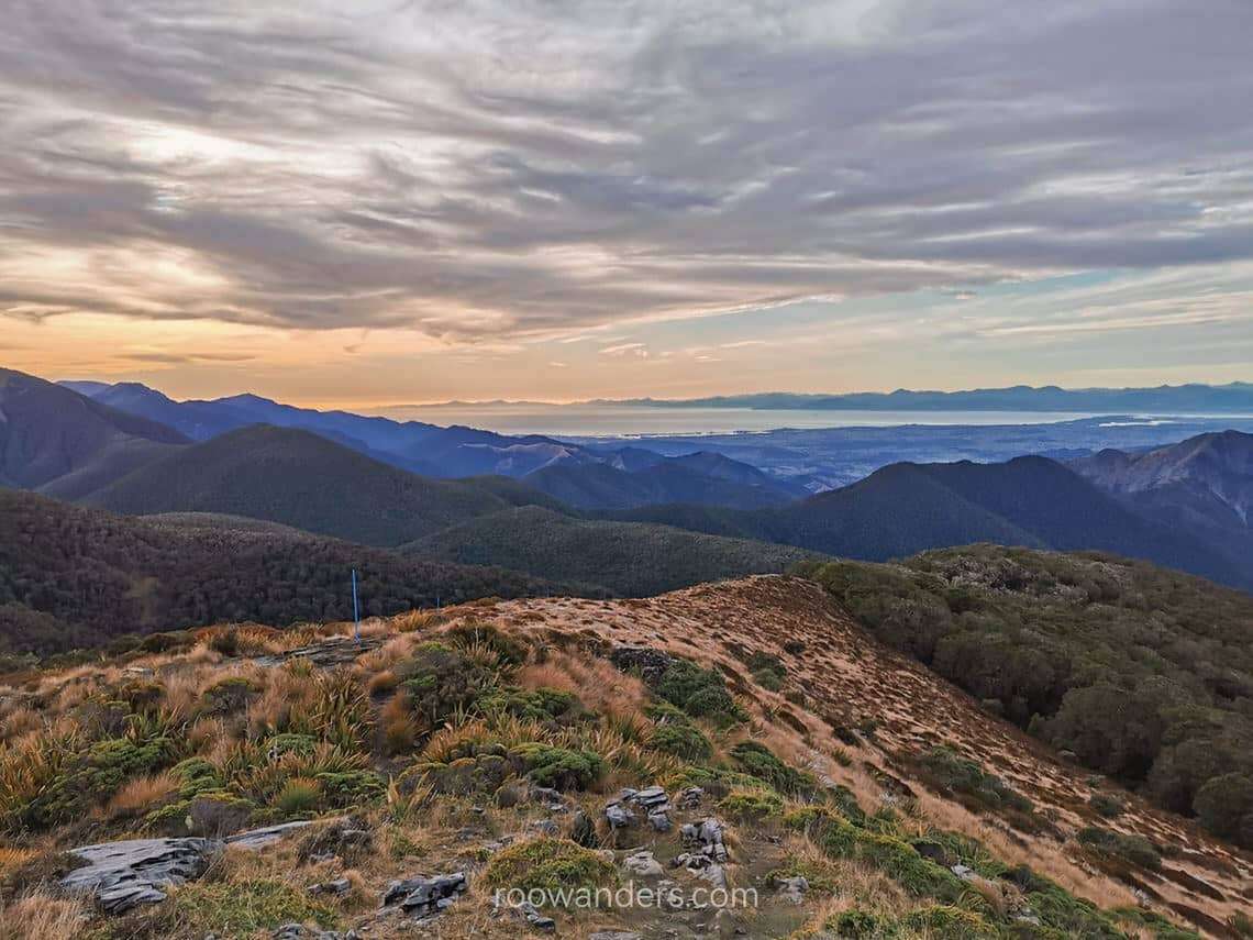
Mount Arthur sits on the border between West Coast and Tasman at the bottom of Kahurangi National Park. The 1795 m summit offers an unblocked visage of the Wharepapa/ Arthur Range and is especially beautiful during winter when the snow blankets the peaks. We were there in May, towards the end of Autumn, and happened to spot patches of snow around Mount Arthur and the adjacent mountains.
There is a hut in-between the carpark and the summit to support those on multi-day tramps like the Ellis Basin Route or Tableland Circuit. Kahurangi National Park has many tramping routes. One of the more notable ones is the Great Walk Heaphy Track that we did later in the year via mountain biking, and the challenging and dangerous Douglas Range Track, which takes more than skills and fitness to complete.
Getting There
The carpark to the entrance of Mount Arthur summit is 75 km away from Nelson and 36 km from Motueka.
The final portion of the road towards the car park was steep and unpaved. Make sure your car is up for the challenge! Take extra caution when driving on it in the dark. DOC recommends a 4-wheel drive during the winter months.

The Trek
The start of the trail was easy. We walked on a wide gravel road in the forest with some undulations here and there but nothing taxing. The beech forest was beautiful; it was shrouded in mist with branches covered in milky green lichen when we were there.
Arthur’s Hut sits on the tree line with possible views of Mount Arthur and the Tablelands on a good day.
The trail started to get interesting after the beech forest. We followed the route through tussock hills on the ridgeline with impressive rock formations here and there, similar to what I encountered on my way to Avalanche Peak at Arthur’s Pass.


The real challenge began with the final leg of rocky scree slopes. We pushed through a narrow gully that was more of a wind tunnel to find ourselves on the rocky plateau of the summit.
What’s at the top? Sweeping visage of the greyish green mountains peppered with white snow and strong and chilly wind. The winds might have swept me off should I stand too close to the edge. That day was gloomy, and we did not have the fortune of a nice warm sun to paint the mountain range vibrant.

After some time playing around the pristine snow around the edge of the mountain, we rerouted the way back and were out of the park by late afternoon.
Pointers to Take Note
- Hydration. It was dry, and there were no natural water sources once we were out of the forest.
- Toilet Stop. Last stop at Arthur’s Hut
- Sun protection. No more shades beyond the bushline.
- Caution. Snow-capped peaks are beautiful, but snow makes the tramp dangerous too. Take caution when hiking during winter conditions. You may have to hire crampons.
Video


You May Also Like
Great Walk Series: Lake Waikaremoana Return
Activities to do in Queenstown
