Great Walk Series: Lake Waikaremoana Return
The last and final Great Walk in New Zealand for me is none other than the sacred lake of Te Urewera – Lake Waikaremoana.
Lake Waikaremoana in the North Island features many exciting activities in a protected forest of the native Tūhoe tribe; however, as I am not a hunter, a fisherman or there for kayaking, we will stick with hiking.
A prelude to this Great Walk: We had just completed the kiwi packing season and were waiting for our next job as lamb rearers in mid-July. That left us a month to rest and travel around the North Island. What else are we missing out on the North Island? Gisborne, and the last (and terribly difficult to access) Great Walk on the North Island.
If you are looking for a guide for the whole track, this is not the post for you. We tracked to and fro the highlight of the tramp – Korokoro Falls – from Onepoto and did not use the water taxi. Read on to understand why we chose to do a return track and not the conventional one-way route.
News Update: Lake Waikaremoana is closed due to severe flooding and will remain closed at least until 30 April 2023.
I trekked Lake Waikaremoana in 2021. This post may be updated periodically.

Where is Lake Waikaremoana
The North Island is almost like a kite if you take away Northland. We have been to all three corners of the island except the eastern part of the island. Look at the map, and you’ll see that Te Urewera National Park, where our last Great Walk is, is nicely positioned between Gisborne and Te Puke.
History of Lake Waikaremoana
A massive landslide aeons ago blocked the river and created Lake Waikaremoana. Underneath this deep lake is a petrified forest with possible dinosaur fossils yet to be discovered. The river lies in the Te Urewera region, the homeland of the Tūhoe people, also known as the Children of the Mist.
More about the Lake
Lake Waikaremoana and its surroundings are a contested region. Hence, unlike the other Great Walks managed by DOC, Lake Waikaremoana is looked after by the Tūhoe community.
While the lake is enclosed, the 46 km track covers only 60% of its perimeter. For those who travel by private transport, you must make arrangements (e.g. an aqua taxi like in Abel Tasman Coast Track) to return to the trailhead where your car is parked. We chose to do away with the hassle and did a return track. Alternatively, trek the remaining 40% boring gravel road back to the carpark.
Getting To Lake Waikaremoana
Travelling to the start of the trek isn’t as easy as driving a highway or two from Te Puke to the park. There are two ways to reach the park, with both trailheads on the horrendous Highway 38.
From Te Puke/ Rotorua to Onepoto carpark
We drove on Highway 33 from Te Puke to Rotorua and then switched to Highway 38 towards Wairoa.
Driving on Highway 38 was a painful experience for someone without a 4WD. The first part of the ride was all nice and smooth on the tarmac until we reached Murupara. Thereafter, it was all portholes and gravel-mud-mix for the next 90 km of the highway.
Our estimated time of arrival was delayed by an hour, and we began the trek slightly after 1 pm.
From Wairoa to Onepoto car park/ Gisborne
The journey out of the park on the remaining section of Highway 38 was much better. We cruised out of Highway 38 towards Gisborne for dinner after the hike.
Best Time to Visit Lake Waikaremoana
Trekking in Lake Waikaremoana is suitable any time of the year. Unlike the other two Great Walks on the North Island – Tongariro and Whanganui – you do not have to climb an avalanche-prone snow peak or canoe down a fast-and-furious post-rain bulging river, which are features of Winter.
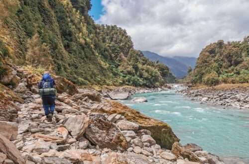
This track is gradual and within a forested area, mostly covered by the elements. Heavy rains may wash away bridges or flood river crossings.

Accommodations for the Trek
Lake Waikaremoana has five huts and five campsites that have to be booked in advance all year round. Most of the campsites are at the second half of the track, between the foot of the Panekire and Hopuruahine Landing.
Since the track is open all year round, it does not enjoy special off-season prices.
It costs NZD 32 for a bunk and NZD 14 for a campsite per person per night. We chose to go with the huts since we were too lazy to carry a tent and sleeping mats.

Water Taxis
If you are a die-hard who must complete the Great Walk, then reserve in advance a water taxi ride back to your starting position. Water taxi services are not available during Winter. It costs about NZD 80 (as of 2023) per adult to travel from the pick-up point (Whananui Hut, the last hut near Hopuruahine) to Onepoto.
My Version of Lake Waikaremoana Return
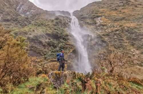
We decided to trek to Korokoro Falls, which is an hour’s return trip from the main track, and re-route our way back to Onepoto. The isolated waterfall is the highlight of Lake Waikaremoana and one of the most beautiful secluded falls in NZ.

Day 1: Onepoto Bay Shelter to Panekire Hut (9 km)
After hours of riding on a bumpy road, we arrived at noon and started our trek proper. A beautiful arch and shelter filled with posters welcomed us, followed by a steep 3-4 km ascent to the Panekire bluff.
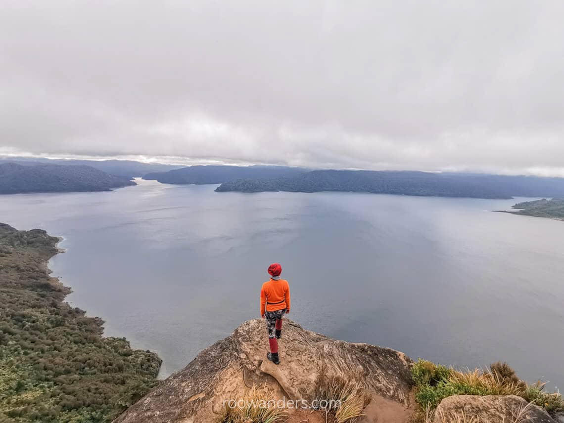
The view from the Panekire bluff is where the cover pages of most blogs and articles covering this trek (mine inclusive) are taken. Several good spots face the lake for great photos, but be careful around the cliff!
The remaining distance was on the undulating ridgeline of Panekire until we reached the hut.
There was no fresh wood or flammable materials for our stay in the hut that night. The wood we foraged from the forest was too wet to set alight. We ended the day early with dinner and snuggling into our warm sleeping bags.

Day 2: Panekire Hut to Korokoro Falls (night at Waiopaoa Hut) (10 km)
We had planned to wake up early and catch the sunrise, but the morning was disappointingly cloudy.
Following a breakfast of oats and nuts, we left Panekire Hut and made our way down the hill, sheltered by trees, until we reached Waiopaoa Hut, where we stopped for lunch.
After refuelling, we left our bags in the hut and continued towards Korokoro Falls. The trail diverged at some point before the Korokoro campsite, and the latter part of the side trip involved some challenging river crossing. We waded through the water – he in jandals while I went barefoot – using a taut metal rope as an assurance.

We then ventured deeper into the secluded forest, the sound of the roaring falls growing louder with every step.
As we approached, the mist churned up by the water turned the surrounding foliage damp and muddy. We reached a vantage point with a clear view of Korokoro Falls, but the cold and damp conditions made it difficult to linger for too long.
On our way back, we retraced our steps, crossing the river once more and merging back onto the main track before arriving back at Waiopaoa Hut just before dark. Waiopaoa Hut was a considerable improvement over Panekire Hut.
Day 3: Back to Onepoto Bay Shelter (17 km)
On the final day of our trek, we retraced our steps from the first day, but this time in reverse. However, there was a notable difference: the winds were unusually fierce, howling through the forest throughout our entire hike.

As we approached the bluff, we paused to take note of the change in weather conditions. Had we not taken the time to marvel at the view from the bluff on Day 1, we wouldn’t have done so in those gusty conditions. A misstep could have been disastrous. I could have been blown off!
Despite the challenging weather, we eventually reached the car park in the late afternoon and hit the road towards Gisborne for dinner.
Tips for Lake Waikaremoana
- Reserve in advance. Make sure you do so for the huts, campsites and water taxis, especially during the peak seasons.
- Water taxis. They do not operate during winter.
- Check the weather. Heavy rain means muddy trails and bloated rivers. Strong winds make standing by the bluff extremely dangerous.
- Pack layers. Do not underestimate the non-alpine huts. It was cold in Panekire Hut.
Buffer time to travel on Highway 38. Get yourself a 4WD.


You May Also Like
Great Walk Series: Milford Return Track | Fiordland
The Copland Track: A West Coast Tramp with Hot Pools
