Great Walk Series #6: Heaphy Track MTB style
My sixth Great Walk in New Zealand!
And also the final one in the South Island.
In case you are wondering, I am on a Great Walk collection spree in New Zealand. There are 10 Great Walks scattered unevenly across the country: seven in the South and three in the North.
We have completed almost all the Great Walks in the South Island, with the Heaphy Track done and dusted.
Almost?
Well, Papamoa Track, the newest track in the South Island, is primarily designed for bikers. Having done Heaphy, which looks similar to Papamoa on the West Coast, we gave that a miss.
Great Walks in the South Island, in order of completion:
- Abel Tasman Coast Track (June)
- Rakuira Track (June)
- Kepler Track (July)
- Routeburn Return Track (July)
- Milford Return Track (Oct)
- Heaphy MTB Track (Oct)
More Great Walks articles here!
Coincidentally, all walks in the South were done during the off-season aka summer-autumn!
Which means mostly having the whole hut to ourselves.
I digressed.
Back to the main plot.
So here is a breakdown of my Heaphy Track on wheels and what you should take note of if you are thinking of doing it too.

What/ Where
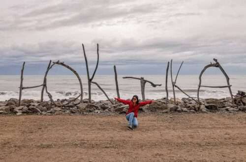
Heaphy Track is located in the Kahurangi National Park, which is in the northwest corner of the South Island. There are several good tracks within this second largest national park of New Zealand (Fiordland NP is the largest) and multiple access points to get to them from these towns: Murchison, Motueka, Takaka, Collingwood and Karamea.
However, for the Heaphy Track, there are only two points to choose from:
- Brown Hut, Golden Bay (from Collingwood)
- Kohaihai, West Coast (from Karamea)
In our case, we decided to go with (1), as we were staying in Motueka.
The 78.4 km one-way route meant that we had to arrange our transport back to the Brown Hut carpark.
You could choose to do the track between 4 – 6 days on foot or 2 – 3 days on wheels (more on this under Track in Brief).
Best Time to Visit
Heaphy Track can be done any time of the year on foot but only between May and Nov if on a bike.
This is a non-alpine track. You do not face dangers associated with the mountains during winter, like avalanches. However, this also meant that bookings must be made in advance all year round since there is no off-season and bunks are not on a first-come-first-serve basis.
Getting There
We chose to enter the track via Brown Hut as we were staying in Motueka. You could stay the night at Motueka/ Takaka/ Collingwood, then make an early drive the next day to the start of the track.
Choosing the starting point as Brown Hut meant you would have to face a huge climb on Day 1, with an elevation increment from 130 m to 920 m.
The other option to conserve energy would be from Kohaihai. That makes the hardest climb on the last day when your bags are the lightest. Most people might have stayed in Karamea (there is a holiday park) before embarking on their multi-tramp/ bike expedition.
Return Transport
Since Heaphy Track is a one-way track, with both ends being over 400 km apart, you would have to book transport arrangements beforehand.
The cost-effective measure would be a bus shuttle. But that means at least 4 hours on the road from the West Coast back to Tasman or vice versa.
We decided to go with an air shuttle because that looks way cooler and way faster.

It costs between $200 to $300 per person for a one-way flight. Many private companies offer this service and several landing points to choose from. Some may need a minimum booking pax before flying.
We flew from Karamea Airport to a grass patch about 4 km away from the Brown Hut carpark.
Accommodation
Book the huts or campsites in advance.
It costs $34/ pp for a bunk bed and $17/ pp for a campsite.
About the Biking Part
I was not entirely sure about my ability to finish the whole track on wheels. Mountain biking was still relatively new to me, and Heaphy Track is a Grade 4 mountain biking track.
But guess what? Somebody watched a video of a plane carrying inverted bikes while tidying the hops saplings and was sold.
My partner and I engaged an avid mountain-biker friend to give us a crash course the day before the track in Kaiteriteri. We went around several loops a few times to get used to our loaned bikes – the life-saving brakes, pedalling on rocks and turning at tight corners.
MTB (mountain biking) is an expensive sport with a high initial cost. The bike could cost over a thousand to buy, and renting one could set you behind a few hundred every day. Not to mention maintaining it.
Lucky for us, this dear friend lent us one of his bikes. We rented another bike from a stall in Kaiteriteri for $120 over three days, including insurance and bags. The bike per se is not a mountain bike with a good suspension system to overcome uneven grounds. But it was a wallet-friendly and sufficient way to complete our mad expedition.
The Track
The 78.4 km one-way route can be completed by foot or bike. You can start from either end of the track, but doing it from the West Coast would be easier as you save the toughest for the last day.
By Foot (as recommended by DOC)
Day 1: Brown Hut > Perry Saddle Hut (17.5 km, 5 h)
750 m height difference, mainly within the forest
Day 2: Perry Saddle Hut > James Mckay Hut (24.2 km, 6 h 30 mins)
Small ups and downs, through some clearings
Day 3: James Mckay Hut > Heaphy Hut (20.5 km, 6 h)
750 height difference, mainly within the forest
Day 4: Heaphy Hut > Kohaihai (16.2 km, 5 h)
Flatland, by the coastal area
By Bike (Our Trip)
Day 1: Brown Hut to Saxon Hut Gouland Downs Hut (24.5 km, 7 h 30 mins)
We were supposed to stay in Saxon Hut but overestimated our abilities and time.
Having left Motueka at 10 am, we started the track in the afternoon. Most of that day was spent pushing the bikes up the rocky slope as it was impossible to cycle up given our level of experience and fitness level.
The steep incline gave way to a much more gradual route once we were out of the forest.
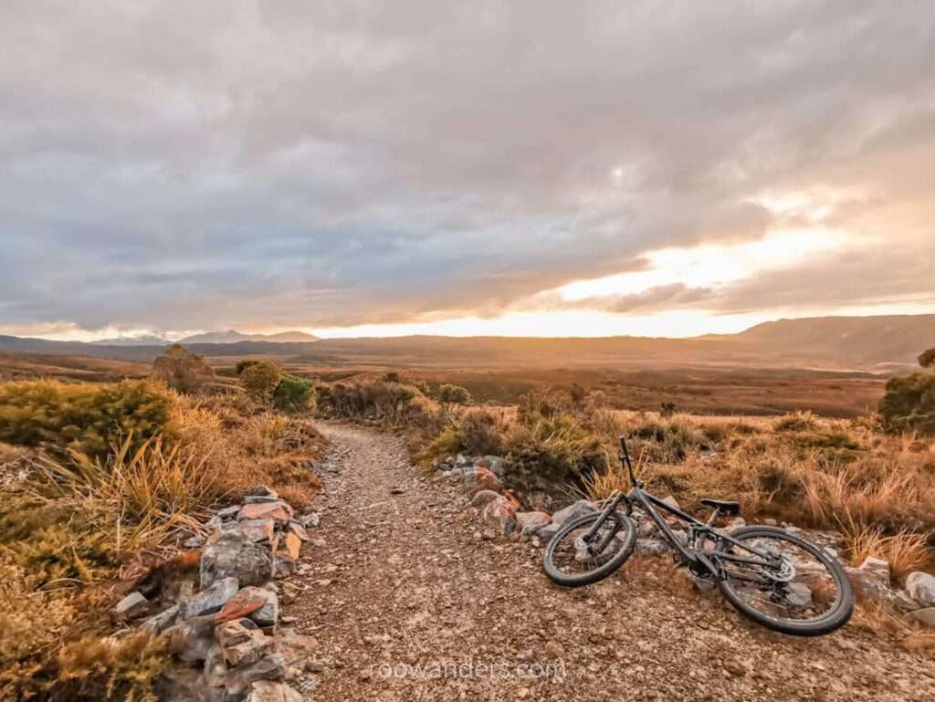
The sunset across the tussock after passing Perry Saddle Hut was gorgeous.

If you have worn-out shoes, you could tie them on a pole like how women are tying old bras on a fence at Cardrona.
We crashed into a reunion party of seven uncles in Gouland Downs Hut as rain poured and the sky turned completely dark. Gouland Downs Hut is small and has only eight bunks. In retrospect, had the uncles refused us, we would have had to brave through rain and darkness to get to Saxon Hut.
Day 2: Gouland Downs Hut to Heaphy Hut (37.7 km, 10 h)
After a day of struggling up, on and off the bike, I woke up feeling sore.
The second day was comparatively easier than day 1 as we managed to cycle across longer distances on flatter terrain.
That day also tested the strength of my wobbly thighs and balance and eventually left me with a few more big black bruises.


There were several bridges to cross, one of which being the 148.8 m-long Heaphy River bridge, the longest suspension bridge ever built by DOC. Some metre-wide planked walkways tested my confidence.
James Mackay Hut was beautiful with gas and electricity.
We saw a helicopter carrying fuel to the hut and spoke to a couple of Korean uncles who have stayed in the hut for two nights. The uncles, and us too, have not seen any Asiatic-face humans do MTB on Heaphy Track.


The route from James McKay Hut to Heaphy Hut was a downhill spiral, literally and figuratively. The person who initiated the MTB plan found it exhilarating to accelerate down the slope without much pedalling while I mostly tumbled and pushed the bike and earned myself a few more medals in the form of ghastly bruises.
At the end of the forest was Lewis Hut – a small and ancient hut with 20 bunks. Last I checked, Lewis Hut was to be demolished and replaced with a shelter by the end of April 2021.


We went back into the forest but on flatter grounds and cycled beneath palm trees.
About 10 mins of pedalling brought us to a big tree.

From then on, it was a flat, sandy road to Heaphy Hut, which was a stone’s throw away from the sea. As with James Mckay Hut, and maybe Perry Saddle Hut, there were electricity and gas in Heaphy Hut.
Day 3: Heaphy Hut to Karamea Airport (35.4 km, 5 hours)
We started our day early on Day 3 as there was a plane to catch at 1.30 pm in Karamea.
This day was about cycling by the beach and hearing and smelling the sea.

After passing through Scotts Beach Campsite, it was back into the forest and over a small hill.
Day cycling from Kohaihai campsite is as popular as from Brown Hut carpark as we encountered several groups of cyclists travelling in the opposite direction.
But what we did not expect was to find a woman who had fallen down the hill. Her blue bike was held by stray branches popping from the side of the hill, while she had slid down the boulders.

We passed by her group moments ago and were wondering when we would meet the last of the pack. It was not until we saw another pair of day hikers standing at the edge and yelling at someone underneath.
The woman’s husband appeared moments later. He peered down, gasped and immediately tried to wrangle his way to his wife.
His wife had broken her arm and could not climb up. One of us (not me) cycled as fast as he could to Kohaihai carpark, where there is reception to call for help.

As scheduled, we cycled to Karamea airport on the tarmac with plenty of grazing livestock on our left and the lashing sea on our right. Along the way, a Saint John’s ambulance whizzed by in the opposite direction.
And there it was, the small plane – our flight back – waiting for us on the concrete.
The flight condensed our 3D2N journey into mere 15 mins.
Pilot Mit was informative throughout the flight, describing the terrain underneath us and pointing to us the different landmarks we have passed over the last three days.
Driver Andy cycled the last 4 km to get to our car at Brown Hut carpark.
We were back in Motueka just before dinner.
Other Noteworthy Items
- Reserve in advance. Applicable all year round for the huts/ campsites and your return transport.
- Check the weather but be prepared. In my opinion, West Coast rains 90% of the time. Rocks can be slippery during rain.
- No cycling at night. DOC’s rule. Plus, it is also dangerous.
- For noobcake, mad bikers like me. Be warned of how challenging this track could be on wheels and with heavy backpacks. If unsure, dismount and push. Even seasoned bikers like the woman can fall and injure themselves at tricky corners.
Video


You May Also Like
West Coast Road Trip: Top Things To Do
The Beautiful Waterfalls of New Zealand