Avalanche Peak Guide from Christchurch
What are some of the great weekend hangouts from Christchurch for someone looking to do some challenging outdoorsy activities? Somewhere not too far out, offers a challenge without requiring expert-level backcountry knowledge, provides back-to-nature vibes, and has a dramatic landscape. The Avalanche Peak, located in Arthur’s Pass, ticks all those boxes!
Location
Arthur’s Pass is about a two hours drive west of Christchurch. To get there, drive on Highway 73. Along the way, you’ll pass Castle Hill, which has its fair share of natural attractions as well, from climbing over rocky formations to spelunking in caves.

Avalanche Peak
According to the official DOC webpage, Avalanche Peak is the only peak with a marked trail.
Arthur’s Pass, as its name suggests, is on the highlands and features several prominent peaks for advanced trekkers, trail runners and rock climbers. The Avalanche Peak is one such peak that allows you the chance – as a fit trekker – to experience how climbing those mountains may have been and enjoy the panoramic view from above.
The marked peak stands erect at 1833 m, with an 1100 m vertical climb.
There are two ways to do this trail – a loop or a return on the same less steep track.
Our Experience
We went with the loop.

Our first stop was to the DOC office, where we checked in with the officer on duty, registered our names, and caught some advice.
Today is a very hot day. Wind conditions look stable. Grab yourself more water.
Avalanche Peak Trail
Then we headed to the start of the trail behind the visitor centre. We started with the Avalanche Peak Trail as the DOC pamphlet suggests.


It was tough, it was steep. I questioned my stamina as we went higher and higher, stomping over rocks and boulders and sometimes even requiring all fours to push ourselves up. Some areas of the trek featured cliffs, and we saw a couple of waterfalls. All this trudging and mindless shuffling happened within the forest. I had to chomp down some dark chocolate to boost my blood sugar. Before we knew it, we had hit the bushline.
Avalanche Peak Route
It was noon by the time we were on the Avalanche Peak Route. The visibility that day was terrific. How could you get bad visibility on a terribly sunny and hot day?
We followed the yellow markers like Hansel and Gretel, over the ridgeline where a tumble could send you rolling down the mountain. Then the greens became less green as the rocks grew in size and number.
A collection of rocks was piled up somewhere in between this track on a certain plateau. In hindsight, it may have been a marking indicating the split between the track we were on – Avalanche Peak Route – and the trail we would descend – Scott’s Track. My guess.
The last push to the summit was crazy. I was hugging the rocks, which jutted out in all directions, while gingerly manoeuvring my limbs to make sure I would not fall off the mountain. Disclaimer: this may be an exaggerated recount coming from someone who does not trust her ankles. I’m sure you’d do better than me.
The last section was definitely scary. I would have listed it as number one if not for Taranaki, which I climbed a month later.
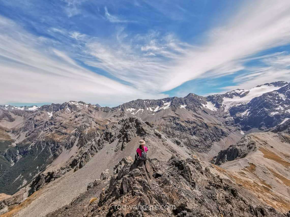
Summit
After spending that much effort and time to reach the peak, the view was, as with all other summits, could only be beautiful. We had an unblocked visage of the whole mountain range and even saw the Crow Glacier and bits of snow on the neighbouring peaks on a sweltering summer afternoon.


There were three Keas on the peak, and we spent quite a long time teasing – or being teased by – them and watching them tumble and play around the dangerous drops – must have been a great life as an alpine parrot.
Scott’s Route + Scott’s Track
Having completed the tougher Avalanche ascent, I thought nothing of this descent. We had lunch in the bushline and saw the famous Devil’s Punchbowl Falls on the opposite mountain. What a small waterfall from our vantage point! But it would have been glamorous if we were down by the falls.


We hurried down the mountain to the road before walking down the road, all sore and tired, to sign off from the visitor centre.
Avalanche Peak – done and dusted within seven hours.
Other Easier Trails
Devil’s Punchbowl is one such easy track which offers minimal effort for maximal reward. It is a 2 km return trail which would take at most an hour to complete.

When visibility on Avalanche Peak is awful, consider changing plans and climbing the easier Bealey Spur Track. It takes about 4 – 5 hours to complete the 6 km loop.
Safety
Having been through the whole loop, I find this mountain doable for anyone with good fitness and stamina. You could see how you fare after climbing the more popular and easier mountains like Roy’s Peak or Isthmus Peak in Wanaka, or Ben Lomond in Queenstown. If you could do those recently, this should be within your fitness level.
Please wear attire meant for hiking. Jeans and sneakers are a big no-no for alpine mountains. They do not provide the grip or flexibility to navigate the mountains.
Attempting this trek during winter is extremely dangerous unless you have the tools and experience to trek on alpine snow.
Finally, people have been seriously injured or died on this trail either from choosing to push on despite poor visibility, losing their way, or falling off the cliff.
Exercise caution and common sense when trekking!
More Tips
- Sunblock, sunscreen, sunshades
- Lots of water
- Inform someone about your intention beforehand/ register with DOC
- Proper and comfortable trekking attire
- Snacks to boost morale
- Start early, and plan to finish the trek before sunset


You May Also Like

Fly Cruise Fly Milford Sound
8 Budget Items To Do In Queenstown